
Ads ADS
» Leica Builder T200 Theodolite - 2,290 USD
» Carlson Explorer II w/ Bluetooth - 1,490 USD
» TDS Ranger 500X w/ Bluetooth & 802.11b WiFi - 2650 USD
» PLS HVR 1000 Laser - 1020 USD
» AGL SLB110 Tunnel Laser - 2100 USD
» TDS Focus 10 – 5 Second Robotic Total Station Package - 17500 USD
» David White ALP8-32 Automatic Level Package - 490 USD
» Satel Epic Base Radio Kit for Sokkia GPS - 2400 USD
» GP3X 3 Gyro Station BT with Dual Display - 40100 USD
» TDS Ranger 500X w/ Bluetooth & 802.11b WiFi - 2,650 USD
» David White DTS05 Total Station - 2,150 USD
» CST Wood/Fiberglass Tripod - 135 USD
» Suunto Tandem Compass/Clinometer - 185 USD
ADS
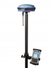
Epoch 35 GNSS Receiver Kit » For sale
Price : 13500 USD
6221-57931816
 Details :
$13,500
The Spectra Precision EPOCH 35 GNSS system uses highly accurate Global Positioning System (GPS) and GLONASS technology for cadastral, topographic, control, stakeout and other precision survey applications. Combining both these satellite services provides the user with the greatest possible satellite coverage, allowing observations in areas where only one satellite solution would not provide results.
The EPOCH 35 is a complete GNSS system that includes a base, rover, field software, data collector, and radio modem. The EPOCH 35 GNSS rover features integrated Bluetooth capability, an internal radio modem and battery. The system runs TDS Survey Pro software operating on the TDS Recon, Nomad, or Ranger data collectors.
With fast, reliable initialization, the EPOCH 35 GNSS is a measurement solution that provides high-quality results in several survey modes including RTK and Static. The system operates without line-of-sight between points, and can be used in any weather. Designed as a multipurpose, integrated system, the EPOCH 35 GNSS system provides total flexibility. Built especially for surveyors, the compact and lightweight EPOCH 35 GNSS integrates the user control interface panel into one powerful measurement solution.
For RTK surveying, the base system may include a choice of radio modems that provide either a short- or long- range data link from the base to the rover. In addition Network RTK is also supported by simply connecting to an external data capable cellular modem. Back at the office, surveyors can use the Spectra Precision Office software for post-processing and quality control.
Features
Affordable GPS + GLONASS integrated receiver
Integrated Bluetooth and Interface Control Panel
RTK real-time positioning
Network RTK positioning
Comprehensive TDS Survey Pro field software
Support for all GNSS data with Spectra Precision Survey Office software
http://www.focus-surveying.com
6221-57931816
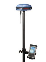
$13,500
The Spectra Precision EPOCH 35 GNSS system uses highly accurate Global Positioning System (GPS) and GLONASS technology for cadastral, topographic, control, stakeout and other precision survey applications. Combining both these satellite services provides the user with the greatest possible satellite coverage, allowing observations in areas where only one satellite solution would not provide results.
The EPOCH 35 is a complete GNSS system that includes a base, rover, field software, data collector, and radio modem. The EPOCH 35 GNSS rover features integrated Bluetooth capability, an internal radio modem and battery. The system runs TDS Survey Pro software operating on the TDS Recon, Nomad, or Ranger data collectors.
With fast, reliable initialization, the EPOCH 35 GNSS is a measurement solution that provides high-quality results in several survey modes including RTK and Static. The system operates without line-of-sight between points, and can be used in any weather. Designed as a multipurpose, integrated system, the EPOCH 35 GNSS system provides total flexibility. Built especially for surveyors, the compact and lightweight EPOCH 35 GNSS integrates the user control interface panel into one powerful measurement solution.
For RTK surveying, the base system may include a choice of radio modems that provide either a short- or long- range data link from the base to the rover. In addition Network RTK is also supported by simply connecting to an external data capable cellular modem. Back at the office, surveyors can use the Spectra Precision Office software for post-processing and quality control.
Features
Affordable GPS + GLONASS integrated receiver
Integrated Bluetooth and Interface Control Panel
RTK real-time positioning
Network RTK positioning
Comprehensive TDS Survey Pro field software
Support for all GNSS data with Spectra Precision Survey Office software
http://www.focus-surveying.com