
Ads ADS
» Sokkia SP1 Pipe Laser - 3590 USD
» AGL EAGL 350 Dual Steep Slope Laser - 4850 USD
» Sokkia DT20C Digital Theodolite - 1590 USD
» TDS Focus 10 - 5 Second Motorized Total Station - 6,550 USD
» Carlson Explorer II w/ Bluetooth - 1,490 USD
» South ET-02 Electronic Theodolite - 650 USD
» DWT-10 Digital Theodolite - 950 USD
» Leica TS02Ultra 3sec Total Station Package - 5,590 USD
» TDS Nomad 800L - 1,590 USD
» Leica Builder T200 Theodolite - 2,290 USD
» AGL SLB110 Tunnel Laser - 2100 USD
» CST Wood/Fiberglass Tripod - 135 USD
» TDS Ranger 500X w/ Bluetooth & 802.11b WiFi - 2,650 USD
ADS
ProMark3 - RTK » For sale
Price : 10900 USD
6221-57931816
 Details :
$10,900
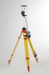
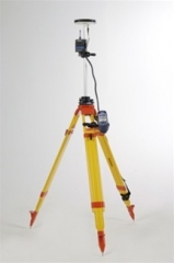
ProMark™3 RTK offers complete real-time GNSS surveying and mobile mapping capabilities on an innovative platform at a remarkably affordable price.
Magellan’s embedded BLADE™ technology, a proprietary GNSS processing solution, enables ProMark3 RTK to outperform other single-frequency RTK receivers, granting real-time performance in the most lightweight handheld system on the market.
An outstanding new GNSS engine, BLADE technology delivers centimeter accuracy for real-time and post-processing surveys and mapping operations. BLADE’s unique GPS+SBAS RTK algorithm ensures quick initialization with single frequency receivers and takes full advantage of the maximum satellite coverage from the dual constellation.
With BLADE built in, ProMark3 RTK is feature rich, precise and reliable.
Based on an advanced, easy-to-use, easy-to-learn technology, ProMark3 RTK is rugged and reliable, offering precision performance even under difficult conditions. If you need an affordable, high-precision GNSS solution, YOU’VE GOT IT! -- with the most popular handheld survey system on the market; ProMark3 RTK.
Expand Your Survey Potential
ProMark3 RTK offers superior GPS capability in a complete range of survey modes, including real-time, real-time + raw data, post-processing and mapping. Ideally suited for short baseline surveys, such as construction site, stake out, and cadastral, ProMark3 RTK is a high-performance positioning, GNSS and mapping solution.
ProMark3 RTK System: Base + Rover
ProMark3 RTK is available as an all-inclusive Base + Rover system with a license-free plug-and-play radio kit. This provides a great advantage when a network is unavailable or when surveying independently from 3rd party data corrections.
The integrated radios conform to the IP65 standard and are directly powered from the receiver and easily configured through a simple menu.
ProMark3 RTK in Network: Rover Only
ProMark3 RTK can be used as a rover only, connected to a real-time network. A Bluetooth connection can be established between ProMark3 RTK and a cellular phone.
ProMark3 RTK is compatible with NTRIP and direct IP and can be connected to any GPS network broadcasting corrections (RTCM 2.3, RTCM 3.1). In this rover configuration the real-time performance of the receiver is linked to the quality of the network (i.e.,distance to the station, interval between stations, VRS quality).
ProMark3 RTK: Post-processing
As with the original ProMark3 receiver, post-processing features are included in ProMark3 RTK. Raw data, simultaneously recorded during RTK jobs, can also be post-processed via the GNSS solutions office software for superior survey integrity. Post-processing ensures full control of the quality of the data collected.
ProMark3 RTK : Mapping
ProMark3 RTK enables you to take any supported GIS file into the field. Easily navigate to field infrastructure for reckon and mapping. Update your GIS data and transfer the file back to the office GIS for the customer.
In mapping mode, ProMark3 RTK delivers decimeter to centimeter-accurate positioning.
Real-time features are fully compatible with previous version of ProMark3.
Features
System Includes
Promark3 Receivers (2)
Radios License Free (2)
Magellan Kinematic Bar Initializer
GNSS Solutions
Promark3 Training DVD
RTK License (2)
Each Receiver Kit Includes :
Carrying Case
GPS ANT L1 NAP100
Promark Bag
GPS Antenna Extension Vertical
H I Tape
Promark3 Field Bracket
Lithium Battery
Promark3 and Promark3 RTK User CD
Mobile Mapper CD
SD Card
http://www.focus-surveying.com
6221-57931816
$10,900
ProMark™3 RTK offers complete real-time GNSS surveying and mobile mapping capabilities on an innovative platform at a remarkably affordable price.
Magellan’s embedded BLADE™ technology, a proprietary GNSS processing solution, enables ProMark3 RTK to outperform other single-frequency RTK receivers, granting real-time performance in the most lightweight handheld system on the market.
An outstanding new GNSS engine, BLADE technology delivers centimeter accuracy for real-time and post-processing surveys and mapping operations. BLADE’s unique GPS+SBAS RTK algorithm ensures quick initialization with single frequency receivers and takes full advantage of the maximum satellite coverage from the dual constellation.
With BLADE built in, ProMark3 RTK is feature rich, precise and reliable.
Based on an advanced, easy-to-use, easy-to-learn technology, ProMark3 RTK is rugged and reliable, offering precision performance even under difficult conditions. If you need an affordable, high-precision GNSS solution, YOU’VE GOT IT! -- with the most popular handheld survey system on the market; ProMark3 RTK.
Expand Your Survey Potential
ProMark3 RTK offers superior GPS capability in a complete range of survey modes, including real-time, real-time + raw data, post-processing and mapping. Ideally suited for short baseline surveys, such as construction site, stake out, and cadastral, ProMark3 RTK is a high-performance positioning, GNSS and mapping solution.
ProMark3 RTK System: Base + Rover
ProMark3 RTK is available as an all-inclusive Base + Rover system with a license-free plug-and-play radio kit. This provides a great advantage when a network is unavailable or when surveying independently from 3rd party data corrections.
The integrated radios conform to the IP65 standard and are directly powered from the receiver and easily configured through a simple menu.
ProMark3 RTK in Network: Rover Only
ProMark3 RTK can be used as a rover only, connected to a real-time network. A Bluetooth connection can be established between ProMark3 RTK and a cellular phone.
ProMark3 RTK is compatible with NTRIP and direct IP and can be connected to any GPS network broadcasting corrections (RTCM 2.3, RTCM 3.1). In this rover configuration the real-time performance of the receiver is linked to the quality of the network (i.e.,distance to the station, interval between stations, VRS quality).
ProMark3 RTK: Post-processing
As with the original ProMark3 receiver, post-processing features are included in ProMark3 RTK. Raw data, simultaneously recorded during RTK jobs, can also be post-processed via the GNSS solutions office software for superior survey integrity. Post-processing ensures full control of the quality of the data collected.
ProMark3 RTK : Mapping
ProMark3 RTK enables you to take any supported GIS file into the field. Easily navigate to field infrastructure for reckon and mapping. Update your GIS data and transfer the file back to the office GIS for the customer.
In mapping mode, ProMark3 RTK delivers decimeter to centimeter-accurate positioning.
Real-time features are fully compatible with previous version of ProMark3.
Features
System Includes
Promark3 Receivers (2)
Radios License Free (2)
Magellan Kinematic Bar Initializer
GNSS Solutions
Promark3 Training DVD
RTK License (2)
Each Receiver Kit Includes :
Carrying Case
GPS ANT L1 NAP100
Promark Bag
GPS Antenna Extension Vertical
H I Tape
Promark3 Field Bracket
Lithium Battery
Promark3 and Promark3 RTK User CD
Mobile Mapper CD
SD Card
http://www.focus-surveying.com